Categories in Maruyama
Maruyama Facts
| Neighborhoods | 2 Chome Maruyama |
| Local Time | |
| Timezone | Japan Standard Time |
| Lat & Lng | 35.46667, 137.16667 |
| Postal Codes | 505 |
Map of Maruyama
Interactive Map
Recent Nearby Earthquakes
Magnitude 3.0 and greater
| Date▼ | Time↕ | Magnitude↕ | Distance↕ | Depth↕ | Location↕ | Link |
|---|---|---|---|---|---|---|
| 3/8/19 | 4:08 PM | 4.5 | 47.8 km | 43,950 m | 3km E of Ogaki, Japan | usgs.gov |
| 10/7/18 | 1:14 AM | 4.8 | 58 km | 40,220 m | 12km N of Shinshiro, Japan | usgs.gov |
| 12/20/17 | 2:34 PM | 4.3 | 24.1 km | 292,860 m | 10km NNE of Mino, Japan | usgs.gov |
| 6/25/17 | 12:24 AM | 4.1 | 56.9 km | 3,810 m | 32km W of Ina, Japan | usgs.gov |
| 6/24/17 | 10:02 PM | 5.2 | 57.1 km | 10,000 m | 35km W of Ina, Japan | usgs.gov |
| 12/6/16 | 12:05 AM | 4.2 | 57.9 km | 10,000 m | 22km SSE of Takayama, Japan | usgs.gov |
| 6/10/16 | 2:12 PM | 4.2 | 26.1 km | 304,330 m | 4km ENE of Konan, Japan | usgs.gov |
| 4/25/16 | 1:00 AM | 4.4 | 45.9 km | 45,500 m | 29km N of Shinshiro, Japan | usgs.gov |
| 3/3/15 | 3:04 PM | 4.6 | 39.4 km | 36,110 m | 1km W of Kasamatsucho, Japan | usgs.gov |
| 2/20/15 | 8:25 PM | 4.3 | 57.6 km | 286,870 m | 20km NNE of Shinshiro, Japan | usgs.gov |
Source: U.S. Geological Survey (USGS)
Maruyama Dam
The Maruyama Dam (丸山ダム, Maruyama Damu) is a dam on the border of Mitake and Yaotsu in Gifu Prefecture, Japan. It was built on the upper reaches of the Kiso River system. It is a gravity dam that is 98.2 m (322 ft) tall. It was built after World War I..
Maruyama Dam Wikipedia Page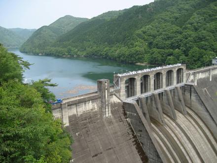


About Our Data
The data on this page is estimated using a number of publicly available tools and resources. It is provided without warranty, and could contain inaccuracies. Use at your own risk.