Categories in Umeda
Auto Parts StoreCommercial PrinterImport Export CompanyWholesalersClothing storesRadio BroadcasterAssociation or OrganizationComputer ConsultantSoftware CompanyArchitecture FirmConstruction of buildingsElectricianPaint StoreEducation CenterCafesGrocery stores and supermarketsIzakaya RestaurantJapanese restaurantsRestaurantsBike Sharing StationBanksTax AttorneyDentistsBeauty salonsHair SalonAdvertising AgencyBusiness Management ConsultantBusiness to Business ServiceCondominium ComplexReal Estate AgencyShoppingHotelsTravel AgencyUnreachable
Industries
Business Distribution by Industry in Umeda
Map of Umeda
Interactive Map
Recent Nearby Earthquakes
Magnitude 3.0 and greater
| Date▼ | Time↕ | Magnitude↕ | Distance↕ | Depth↕ | Location↕ | Link |
|---|---|---|---|---|---|---|
| 6/10/19 | 7:30 PM | 4.2 | 36.1 km | 366,200 m | 5km NW of Muko, Japan | usgs.gov |
| 10/27/18 | 11:51 AM | 4.4 | 48 km | 68,080 m | 1km SSW of Yoshino-cho, Japan | usgs.gov |
| 7/8/18 | 6:45 AM | 3.8 | 29.5 km | 10,000 m | 4km SSW of Kameoka, Japan | usgs.gov |
| 6/23/18 | 2:08 PM | 3.9 | 21 km | 10,000 m | 2km NE of Hirakata, Japan | usgs.gov |
| 6/18/18 | 10:52 PM | 3.7 | 15.6 km | 10,000 m | 1km ENE of Neyagawa, Japan | usgs.gov |
| 6/18/18 | 3:31 PM | 4.6 | 14 km | 10,000 m | 2km NNW of Neyagawa, Japan | usgs.gov |
| 6/17/18 | 10:58 PM | 5.5 | 18.7 km | 10,340 m | 1km NW of Hirakata, Japan | usgs.gov |
| 3/25/16 | 10:20 AM | 4.2 | 51.2 km | 375,700 m | 9km S of Haibara, Japan | usgs.gov |
| 11/24/15 | 4:07 AM | 3.4 | 41.2 km | 10,000 m | 1km SW of Kyoto, Japan | usgs.gov |
| 11/17/14 | 9:07 PM | 4.3 | 41.6 km | 14,540 m | 8km ESE of Akashi, Japan | usgs.gov |
Source: U.S. Geological Survey (USGS)
Umeda
Umeda (梅田) is a major commercial and business district in Kita-ku, Osaka, Japan, and the city's main northern railway terminus (Ōsaka Station, Umeda Station). area is notable for its comparatively high concentration of tall buildings, of which those..
Umeda Wikipedia Page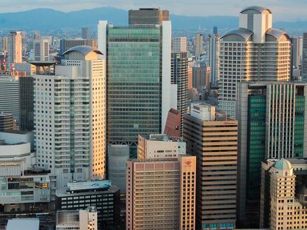

About Our Data
The data on this page is estimated using a number of publicly available tools and resources. It is provided without warranty, and could contain inaccuracies. Use at your own risk.