Businesses in Aluminé
Hotels & Travel
Restaurants
Automotive
Financial Services
Medical
Beauty & Spas
Community & Government
Industries
Business Distribution by Industry Hotels & Travel: 23.5%
Shopping: 17.3%
Food: 10.1%
Restaurants: 6.1%
Education: 5.8%
Sports & Activities: 4.9%
Other: 32.3%
| Area of Aluminé, Neuquén Province | 1.303 km² |
| Population | 5,357 |
| Population change from 1975 to 2015 | +169.2% |
| Population change from 2000 to 2015 | +29.4% |
| Area Codes | 2942 |
| Local Time | Thursday 11:04 PM |
| Timezone | Argentina Standard Time |
| Lat & Lng | -39.23686° / -70.9197° |
Aluminé, Neuquén Province - Map
Aluminé, Neuquén Province Population
Years 1975 to 2015| Data | 1975 | 1990 | 2000 | 2015 |
|---|---|---|---|---|
| Population | 1,990 | 3,410 | 4,139 | 5,357 |
| Population Density | 1,527 / km² | 2,617 / km² | 3,176 / km² | 4,111 / km² |
Aluminé Population change from 2000 to 2015
Increase of 29.4% from year 2000 to 2015| Location | Change since 1975 | Change since 1990 | Change since 2000 |
|---|---|---|---|
| Aluminé, Neuquén Province | +169.2% | +57.1% | +29.4% |
| Neuquen | +105.6% | +51.9% | +27.4% |
| Argentina | +66.4% | +32.6% | +17.1% |
Aluminé, Neuquén Province Population Density
Population Density: 4,111 / km²| Location | Population | Area | Population Density |
|---|---|---|---|
| Aluminé, Neuquén Province | 5,357 | 1.303 km² | 4,111 / km² |
| Neuquen | 613,365 | 94,454.9 km² | 6.49 / km² |
| Argentina | 43.2 million | 2,779,516.9 km² | 15.5 / km² |
Aluminé, Neuquén Province Historical and Projected Population
Estimated Population from 1890 to 2100Sources:
1. JRC (European Commission's Joint Research Centre) work on the GHS built-up grid
2. CIESIN (Center for International Earth Science Information Network)
3. [Link] Klein Goldewijk, K., Beusen, A., Doelman, J., and Stehfest, E.: Anthropogenic land use estimates for the Holocene – HYDE 3.2, Earth Syst. Sci. Data, 9, 927–953, https://doi.org/10.5194/essd-9-927-2017, 2017.
Human Development Index (HDI)
Statistic composite index of life expectancy, education, and per capita income.Sources: [Link] Kummu, M., Taka, M. & Guillaume, J. Gridded global datasets for Gross Domestic Product and Human Development Index over 1990–2015. Sci Data 5, 180004 (2018) doi:10.1038/sdata.2018.4
Aluminé, Neuquén Province CO2 Emissions
Carbon Dioxide (CO2) Emissions Per Capita in Tonnes Per Year| Location | CO2 Emissions | CO2 Emissions Per Capita | CO2 Emissions Intensity |
|---|---|---|---|
| Aluminé, Neuquén Province | 25,232 tn | 4.71 tn | 19,364 tons/km² |
| Neuquen | 2,917,972 tn | 4.76 tn | 30.9 tons/km² |
| Argentina | 198,107,944 tn | 4.59 tn | 71.3 tons/km² |
Aluminé, Neuquén Province CO2 Emissions
| 2013 CO2 emissions (tonnes/year) | 25,232 tn |
| 2013 CO2 emissions (tonnes/year) per capita | 4.71 tn |
| 2013 CO2 emissions intensity (tonnes/km²/year) | 19,364 tons/km² |
Natural Hazards Risk
Relative risk out of 10| Earthquake | Medium (6) |
* Risk, particularly concerning flood or landslide, may not be for the entire area.
Sources: 1. Dilley, M., R.S. Chen, U. Deichmann, A.L. Lerner-Lam, M. Arnold, J. Agwe, P. Buys, O. Kjekstad, B. Lyon, and G. Yetman. 2005. Natural Disaster Hotspots: A Global Risk Analysis. Washington, D.C.: World Bank. https://doi.org/10.1596/0-8213-5930-4.
2. Center for Hazards and Risk Research - CHRR - Columbia University, Center for International Earth Science Information Network - CIESIN - Columbia University. 2005. Global Earthquake Hazard Distribution - Peak Ground Acceleration. Palisades, NY: NASA Socioeconomic Data and Applications Center (SEDAC). https://doi.org/10.7927/H4BZ63ZS.
Recent Nearby Earthquakes
Magnitude 3.0 and greater| Date | Time | Magnitude | Distance | Depth | Location | Link |
|---|---|---|---|---|---|---|
| 11/26/18 | 6:12 AM | 4.6 | 80.8 km | 159,810 m | 31km WNW of Junin de los Andes, Argentina | usgs.gov |
| 10/17/18 | 3:34 AM | 4.4 | 98.9 km | 151,980 m | 44km NW of San Martin de los Andes, Argentina | usgs.gov |
| 9/3/18 | 5:20 PM | 4.7 | 89.3 km | 140,010 m | 47km NNW of San Martin de los Andes, Argentina | usgs.gov |
| 12/26/17 | 11:09 AM | 4.2 | 66 km | 190,250 m | 26km SSW of Las Lajas, Argentina | usgs.gov |
| 6/23/17 | 3:00 AM | 5 | 77.9 km | 115,450 m | 17km SE of Pucon, Chile | usgs.gov |
| 3/4/16 | 3:50 PM | 4.1 | 83 km | 106,560 m | 51km ESE of Vilcun, Chile | usgs.gov |
| 6/5/13 | 9:26 AM | 4.1 | 36.3 km | 139,700 m | Neuquen, Argentina | usgs.gov |
| 4/23/11 | 10:28 PM | 4.3 | 15.3 km | 156,200 m | Neuquen, Argentina | usgs.gov |
| 3/1/10 | 6:09 PM | 5.1 | 69.6 km | 24,800 m | Neuquen, Argentina | usgs.gov |
| 9/5/08 | 7:28 PM | 4.2 | 40.1 km | 145,800 m | Neuquen, Argentina | usgs.gov |
Find historical earthquake occurrences near Aluminé, Neuquén Province
Earliest Date Latest Date
Magnitude 3.0 and greater Magnitude 4.0 and greater Magnitude 5.0 and greater

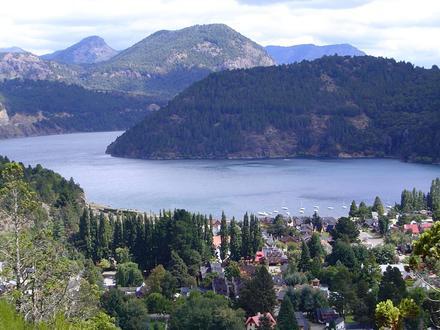
Aluminé, Neuquén Province
Aluminé is a second class municipality and the capital city of Aluminé Department located in Neuquén Province, Argentina. Aluminé Wikipedia Page
About Our Data
The data on this page is estimated using a number of publicly available tools and resources. It is provided without warranty, and could contain inaccuracies. Use at your own risk. See here for more information.